All infrastructure should be inspected and monitored regularly in order to prevent failures. Among many measured data from the infrastructure, the geolocation of the collected data should also be recorded.
Standards like EN 50317 define the parameters and the required precision of each parameter that should be recorded. But most of these standards didn’t define the minimum acceptable precision of the positioning system. In this article, the effect of the precision of the positioning system is discussed for the aim of inspection, real-time monitoring, and predictive maintenance.
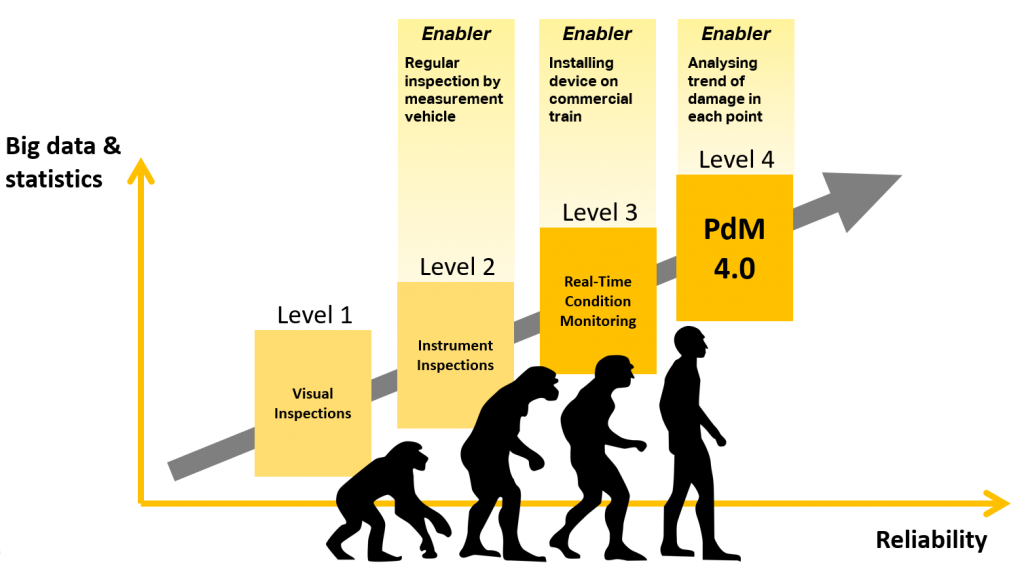
At first, it is better to highlight the difference between prediction, real-time monitoring, and predictive maintenance.
In this picture, the Predictive maintenance maturity matrix plus the required enabler for each level is illustrated.
The measurement train (Level 2) inspects the rail and overhead catenary system once a while (6 or 12 months). In this case, any location of the problematic case in the line can be reported with 10-20 meter accuracy because the report will be a task ticket for the maintenance crew. They can find the problematic point as soon as they get close to the point.
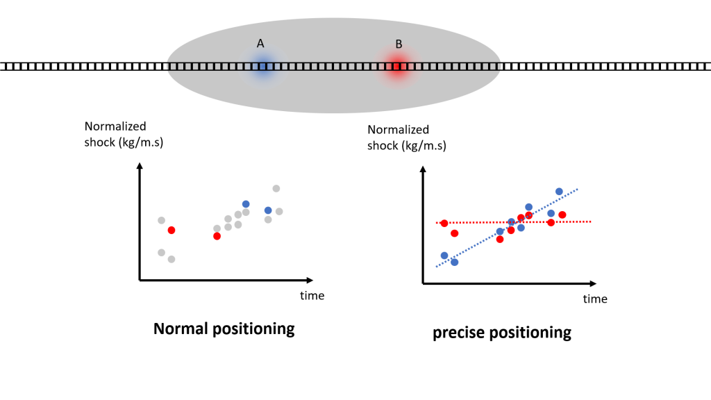
For monitoring (Level 3), the application of fault positioning is quite similar to the inspection. Therefore the precise positioning is not nearly required.
In fact, in level 2 and level 3 of the maintenance maturity, the positioning can be done in 2 steps: first, low precision positioning system of measurement train or the monitoring train. Then the visual inspection of the maintenance crew will act as the precise positioning. But for level 4 of maintenance maturity, all data collection and annotation should be accomplished because a large amount of data is required, and it is not feasible to annotate data via the visual method. Therefore the precise positioning is not an option for predictive maintenance of infrastructures.
To highlight the importance of precise positioning in the application of predictive maintenance of infrastructure, another example is the ID number of each point. In the predictive maintenance concept, each point has its P-F (potential failure) curve. The geolocation plays the role of identification number (ID) of each point. In a normal positioning system, it is possible that two different points are reporting and archiving with the same ID. This fact makes doubt and uncertainty in the database of your prediction system.
Thanks to Deutsche Telekom and Swift technology, the PANTOhealth monitoring solution is equipped with a precise positioning system with an accuracy of 10 cm. It means the problematic points with a distance of more than 10cm can be distinguished and classified in the data based on PANTOhealth.
We use cookies to personalize content, analyze our traffic, and enhance your browsing experience. Some of these cookies may collect basic personal data such as your browsing preferences. By clicking "Accept," you consent to our use of cookies and the processing of your data. If you do not consent, please leave this website.
Strictly Necessary Cookies
Strictly Necessary Cookie should be enabled at all times so that we can save your preferences for cookie settings.
If you disable this cookie, we will not be able to save your preferences. This means that every time you visit this website you will need to enable or disable cookies again.